If you buy through affiliate links, we may earn commissions, which help support our product reviews.
Last Updated: Jan 5, 2024
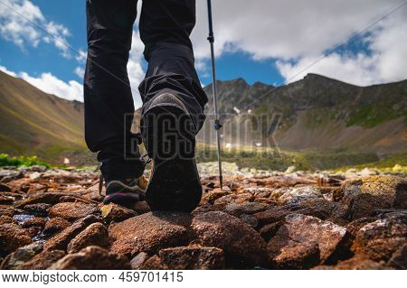
When it comes to choosing a GPS device for hiking, there are a few key factors to consider.
First and foremost, you’ll want a device that is reliable and accurate. You don’t want to be hiking in the wilderness with a GPS that is constantly giving you wrong or conflicting information.
One important feature to look for is a high-resolution display. A clear and easy-to-read display is essential for navigation, especially if you’ll be using the device in low-light conditions, areas with poor visibility, or direct sunlight.
Another important feature for a hiking GPS is long battery life. You don’t want your device to run out of power in the middle of a hike, so consider choosing a device with a battery that can last for several days or even weeks.
Check out solar GPS watches that recharge in the sun while you hike.
Durability is also an important consideration. Hiking can be tough on electronics, so you’ll want a device that can handle the elements and any accidental drops or impacts and has an IP67 waterproof rating.
Some other features to consider when choosing a GPS for hiking include:
- Detailed maps: Look for a device that comes with detailed topographic maps of the area you’ll be hiking in. These maps can help you plan your route and give you a better sense of the terrain.
- Waypoint tracking: This feature allows you to mark your current location and return to it later. This can be especially useful if you get lost or want to revisit a particular location.
- Compass: A built-in compass can be helpful for navigation, especially if you don’t have a physical compass with you.
- Altimeter: An altimeter can help you track your elevation and monitor your ascent and descent.
For more on safety devices, check out our article on the best personal locator beacons.
Some popular GPS devices for hiking include the following:
Ultimately, the best GPS for you will depend on your specific needs and budget. It’s a good idea to do some research and read reviews from other hikers before making a decision.
Some of these handheld GPS devices for hiking can also be used for car GPS navigation because they can use both topographical maps and road maps.
For cyclists who require more specialized features such as GPS and maps, check out our article on the best cycle computers with GPS and maps. This guide will help you find a device tailored to your cycling needs, offering detailed insights into various models and their capabilities.
If you’re venturing into areas where a marine GPS might be more suitable, such as coastal trails or combining hiking with kayaking, you may want to consider the features of handheld marine GPS units. These devices are specifically designed to withstand marine environments and can be an invaluable tool for coastal navigation. Learn more about handheld marine GPS units.
Best Handheld GPS for Hiking & Navigation (Reviewed in 2024)
Garmin eTrex 32x Rugged Handheld GPS Navigator
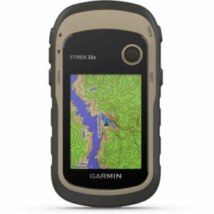 Power Source: AA Batteries or Mini-USB
Battery Life: 25 Hours
Memory Storage: 8 GB
Display: 2.2 inches, 240 x 320
Data Connection: USB, microSD, ANT+
Spoken Directions: No, but routing
Preloaded MAPS: Yes, Topographical
Dimensions: 4.0 x 2.1 x 1.3 inches
Setup & Install Experience:
These Garmin handhelds are popular. This one comes with a suction mount and cigarette lighter power cable.
You can choose between the – S version which links to your smartphone to pull live traffic alerts via the free Garmin Smartphone Link app. The internal lithium battery will only last 1 hour should you decide to use it that way.
They also support the ANT wireless protocol for data transmission.
Pros
- Easy Setup;
- Spoken Turns & Alerts;
- External USB storage;
- Shows Elevation;
- Lifetime Map updates;
- 1 Year Warranty;
Cons
- Does not include Alaska;
Performance & Overall Experience:
The Garmin eTrex 32 is great as a handheld device. We found this a great experience and easy to use.
The display looks great and can be seen at a normal distance.
They have a Garmin Express app that lets you backup the data to your computer as well as import waypoints from another mapping device.
It also supports other languages and can save up to 1000 locations.
Tested Features:
- Live alerts and turns tested.
- Recalculates routes.
- Built-in speaker.
- Historical trips log.
- Customize routes to avoid certain terrain.
- POI data
Garmin GPSMAP 64sx, Portable GPS with Altimeter and Compass
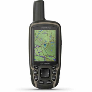 Power Source: AA Batteries or Mini-USB
Battery Life: 16 Hours
Memory Storage: 8 GB
Display: 2.6 inches, 160 x 240
Data Connection: USB, microSD, Bluetooth, ANT+
Spoken Directions: No, but routing
Preloaded MAPS: Yes, Topographical
Dimensions: 6.3 x 1.4 x 2.4 inches
Setup & Install Experience:
These Garmin 64sx handhelds are popular. This one comes with a suction mount and cigarette lighter power cable.
We like the high-sensitivity receiver with quad helix antenna and multi-GNSS support (GPS, GLONASS and Galileo) and 3-axis compass with barometric altimeter and wireless connectivity via BLUETOOTH technology and ANT+.
These handheld GPS receivers work without the need for Internet or data. Maps are preloaded.
Pros
- Easy Setup;
- Spoken Turns & Alerts;
- External USB storage;
- Shows Elevation;
- Lifetime Map updates;
- 1 Year Warranty;
Cons
- Does not include Alaska;
Performance & Overall Experience:
The Garmin 51 is great with the -S version which links to your smartphone. We found this a better experience with live updates.
The display looks great and can be seen at a normal handheld distance.
They have a Garmin Express app that lets you backup the data to your computer as well as import waypoints from another mapping device.
It also supports other languages and can save up to 1000 locations.
Tested Features:
- Live alerts and turns tested.
- Recalculates routes.
- Built-in speaker.
- Historical trips log.
- Customize routes to avoid hazardous terrain.
- POI data
Garmin eTrex 10 Worldwide GPS Handheld Navigator
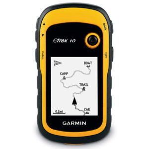 Power Source: Battery or Mini-USB
Battery Life: 6 Hours
Memory Storage: 32 GB
Display: 5.5 inches, 1280 x 720
Data Connection: USB, microSD, Wi-Fi, ANT+
Spoken Directions: No, but routing
Preloaded MAPS: Yes, US
Dimensions: 5.8 x 1.0 x 3.5 inches
Setup & Install Experience:
These Garmin handhelds are popular. This one comes with a suction mount and cigarette lighter power cable.
You can choose between the – S version which links to your smartphone to pull live traffic alerts via the free Garmin Smartphone Link app. The internal lithium battery will only last 1 hour should you decide to use it that way.
Pros
- Easy Setup;
- Spoken Turns & Alerts;
- External USB storage;
- Shows Elevation;
- Lifetime Map updates;
- 1 Year Warranty;
Cons
- Does not include Alaska;
Performance & Overall Experience:
The Garmin eTrex 10 is great with the base maps which links to your smartphone. We found this a better experience with live updates.
The monochrome display looks great and can be seen at a normal handheld distance.
They have a Garmin Express app that lets you backup the data to your computer as well as import waypoints from another mapping device.
It also supports other languages and can save up to 1000 locations.
Tested Features:
- Live alerts and turns tested.
- Recalculates routes.
- Built-in speaker.
- Historical trips log.
- Customize routes to avoid some terrain.
- POI data
Garmin GPSMAP 66i, Hiking Handheld GPS and 2-Way Satellite Communicator
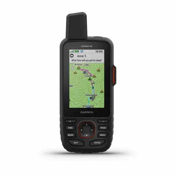 Power Source: AA Batteries or Mini-USB
Battery Life: 35 Hours, 200 Power save
Memory Storage: 16 GB
Display: 3 inches, 240 x 400
Data Connection: USB, microSD, Wi-Fi, Bluetooth, ANT+
Spoken Directions: No, but routing
Preloaded MAPS: Yes, Topographical
Dimensions: 6.4 x 1.4 x 2.5 inches
Setup & Install Experience:
These Garmin 2-way handhelds are nice to have when hiking or in remote locations. This one comes with a suction mount and cigarette lighter power cable.
You can choose between the WikiLok App version which links to your smartphone to download hiking maps. The internal lithium battery will last 200 hours with 35 minute tracking.
It comes loaded with TopoActive maps for US and Canada, and can use custom maps.
Pros
- Easy Setup;
- Spoken Turns & Alerts;
- External USB storage;
- Shows Elevation;
- Lifetime Map updates;
- 1 Year Warranty;
Cons
- Does not include Alaska;
Performance & Overall Experience:
The Garmin 66i is great as a portable mapping system. Even though the 2-way satellite communication requires a subscription, that is well worth it when you are on land or water. Starts at $12 per month.
The 66sr version has the same features without the 2-way communication, text messages, email, sos, etc.
The display looks great and can be seen at a normal distance and in sunlight.
They have a Garmin Express app that lets you backup the data to your computer as well as import waypoints from another mapping device.
It also supports other languages and can save up to 1000 locations. This unit can even support inland and coastal water charts for a great portable marine GPS navigation system as well as road maps for driving.
Tested Features:
- Live alerts and turns tested.
- Recalculates routes.
- Built-in speaker.
- Historical trips log.
- Customize routes to avoid certain areas.
- POI data
Garmin Montana 700i, Rugged GPS Handheld with Built-in inReach Satellite Technology
 Power Source: AA Batteries or Mini-USB
Battery Life: 18 Hours, 300 Power Save
Memory Storage: 16 GB
Display: 5 inches, 480 x 800
Data Connection: USB, microSD, Wi-Fi, Blueooth, ANT+
Spoken Directions: No, but routing
Preloaded MAPS: Yes, Topographical
Dimensions: 7.2 x 1.3 x 3.6 inches
Setup & Install Experience:
These Garmin handhelds are popular. This one comes with a suction mount and cigarette lighter power cable.
You can choose between the – S version which links to your smartphone to pull live traffic alerts via the free Garmin Smartphone Link app. The internal lithium battery will only last 1 hour should you decide to use it that way.
Also, it only includes the lower 49 states, not Alaska.
Pros
- Easy Setup;
- Spoken Turns & Alerts;
- External USB storage;
- Shows Elevation;
- Lifetime Map updates;
- 1 Year Warranty;
Cons
- Does not include Alaska;
Performance & Overall Experience:
The Garmin 700i is great with the -S version which links to your smartphone. We found this a better experience with live updates.
The display looks great and can be seen at a normal hiking distance.
They have a Garmin Express app that lets you backup the data to your computer as well as import waypoints from another mapping device.
It also supports other languages and can save up to 1000 locations.
Tested Features:
- Live alerts and turns tested.
- Recalculates routes.
- Built-in speaker.
- Historical trips log.
- Customize routes to avoid certain hiking routes.
- POI data
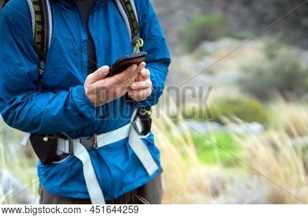
How to use your Phone as a GPS for Hiking
Did you know, using your phone as a GPS device for hiking can be a convenient and cost-effective option, as long as you have a reliable signal and enough battery life. Here are a few steps to follow to use your phone as a GPS for hiking:
- Download a mapping app: There are several apps available that allow you to use your phone as a GPS device. Some popular options include Google Maps, Apple Maps, and Waze. These apps allow you to see your location on a map and get turn-by-turn directions.
- Download offline maps: If you’ll be hiking in an area with limited or no cell service, you’ll want to download offline maps of the area beforehand. This will allow you to access the map and your location even when you don’t have a cell signal.
- Carry a portable battery pack: It’s a good idea to bring a portable battery pack with you on your hike to ensure you have enough power for your phone.
- Keep your phone charged: Make sure to keep your phone charged throughout your hike. If you have a device with a removable battery, consider bringing a spare battery or a battery pack that allows you to swap out the battery on the go.
- Enable location services: In order for your phone to accurately track your location, you’ll need to make sure location services are enabled. This can usually be done in the settings menu of your phone.
- Follow the map: Once you have your phone set up and your location determined, you can use the map to navigate your hike. The app will show your current location and provide directions to your destination.
Using your phone as a GPS for hiking can be a convenient and efficient way to navigate the trails, as long as you have a reliable signal and enough battery life. See the differences between a GPS and Google Maps.
Just make sure to take the necessary precautions to ensure your phone stays powered and protected during your hike or turn it off when not needed.
What are the Best Phone Apps for Hiking
There are many great apps available for hikers that can help with everything from trip planning and navigation to finding trails and tracking your progress.
Here are a few popular options:
- AllTrails: This app allows you to search for and discover new trails, view detailed maps and elevation profiles, and track your hikes using GPS. It also includes features like a trail finder, weather forecast, and the ability to save and share your hikes.
- Gaia GPS: This app offers a wide range of mapping and navigation tools for hikers, including topographic maps, satellite imagery, and the ability to download maps for offline use. It also includes features like waypoint tracking, a trip planner, and a compass.
- Hiking Project: Developed by REI, this app features detailed trail maps and elevation profiles for over 75,000 trails in the United States. It also includes features like real-time trail conditions, photos and reviews from other hikers, and the ability to track your hikes and share them with others.
- MapMyHike: This app allows you to track and log your hikes, view maps and elevation profiles, and set goals and challenges for yourself. It also includes features like a calorie tracker and the ability to connect with other hikers and share your progress.
- ViewRanger: This app offers a wide range of mapping and navigation tools for outdoor enthusiasts, including topographic maps, satellite imagery, and the ability to download maps for offline use. It also includes features like waypoint tracking, a compass, and the ability to share your adventures with others.
Ultimately, the best hiking app for you will depend on your specific needs and preferences. Many of these apps offer free and paid versions, so you can try out a few and see which one works best for you.
Is a Hiking GPS worth it?
Yes, even if you don’t use it. There may be a situation where you need to send your exact location in case of an emergency.
How do I Choose a GPS for Hiking?
Depends on your needs for the size and type of GPS navigation and where you are hiking.